
It’s easy to forget that the sun isn’t the uniformly glowing orb it appears to be from Earth. In actuality, the sun is a tumultuous ball of nuclear explosions. Although those explosions don’t usually affect us in a physical way on Earth, they do affect the thousands of satellites orbiting our planet that control things like GPS and communications services we depend on everyday.
Frank Eparvier and his team at the Laboratory for Atmospheric and Space Physics (LASP) keep an eye on those solar explosions and how they impact the Earth and the Earth-space environment in a relatively new field known as space weather.
“Because it’s of such vital importance to commerce and security, everything to do with the running of our country has some tie into weather or space weather,” said Eparvier.
NASA enlisted Eparvier and his team at LASP to build a tandem set of instruments that monitor solar activity. The instruments, collectively referred to as the Extreme Ultraviolet and X-ray Irradiance Sensors (EXIS), detect solar variations and changes to the ionosphere via an Extreme UltraViolet Sensor (EUVS) as well as solar flares and x-ray output from the sun using an X-Ray Irradiance Sensor (XRS).
The technology in the EXIS instruments is unprecedented thanks to a study Eparvier led with scientists at LASP that resulted in a total redesign.
“The improvement that our instrument will have over past instruments is the larger dynamic range,” said Eparvier. “We’ll be able to measure smaller values and much, much larger values. We will know very accurately and precisely the amount of energy coming from the sun.”
“We should now be able to see the full variability of the sun,” said Eparvier.
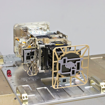
The EXIS instruments, built by LASP scientists, are complete with a CU buffalo.
Image courtesy of LASP.
Improvements in space weather prediction and monitoring are becoming more and more imperative as modern society increasingly relies on the communications services satellites provide. Solar flares and other radioactive ejections from the sun influence not only the composition of the upper atmosphere but also its charged state. When space weather events ionize the upper atmosphere, it can disrupt coordination between our GPS systems and the satellites. As a result, the satellite appears as if it’s in the wrong place above Earth. If the GPS technology doesn’t know to correct for these changes, it can give you a false indication of your position.
While a GPS that tags you at the incorrect location may be inconvenient for your Fit Bit tracking, it carries more dire consequence for navigation operations like directing submarines through narrow channels, coordinating the hundreds of commercial airplanes that fly into and out of the nation’s airports everyday, and providing situational awareness to U.S. military operations around the globe.
Large flares from the sun can send out a lot of energy toward Earth in the form of x-rays, extreme UV light, and magnetic fields. Radiation from these flares can also heat the upper atmosphere causing it to expand. This alters the density of the upper atmosphere through which satellites are navigating, and this change creates drag. Mission operators must then adjust the orbit of satellites to accommodate for the drag, which uses valuable fuel in the process.
And, changes to the ionosphere can induce currents in electrical wires, as well as oil and gas pipelines here on Earth.
The groundbreaking technology in the EXIS instruments will allow for proactive and timely responses to space weather events.
EXIS will launched aboard the NOAA GOES-R satellite from Cape Canaveral, Fl. on November 19. Once in place, GOES-R (the Geostationary Operational Environment Satellite series R) will hover about 22,000 miles above the equator over the western hemisphere while providing unparalleled weather and space weather monitoring and forecasting.

GOES-R launched aboard the ATLAS V rocket from Cape Canaveral, Fl. on November 19, 2016.
Image courtesy of NASA/NOAA.
GOES-R is the latest in a series of satellites that have been around since 1975 to monitor weather and, more recently, space weather.
“Anytime you see any satellite imagery on the web, on the news, on TV, it all comes from the GOES satellites,” said Eparvier.
Together with new instrumentation that maps lightning strikes and measures shifts in the electromagnetic field of the upper atmosphere, GOES-R will provide continuous imaging with enhanced resolution for more accurate Earth weather forecasts and unmatched solar activity monitoring.
From military operations to harvesting cornfields by GPS-directed combines, our modern, technology-fueled life depends on our ability to predict and respond to space weather incidents.
The new capabilities of the LASP-built EXIS will enable space weather forecasters to provide the most accurate information they’ve ever had in making critical decisions to protect our ever-growing technological infrastructure.
By Roni Dengler
