Trees perform a vital role in the respiratory cycle of our planet Earth. They provide homes for a vast array of species and the raw materials for constructing much of the human world. Their ubiquity on the earth’s surface demonstrates their hardiness and adaptability to a wide range of climates, but they are also remarkably fragile to some environmental variables and events.
One tree can be affected by a wide range of perturbations: fire, drought, and infestations to name a few. And just as a doctor can only perform a physical one patient at a time, biologists can only physically check one tree at a time. Given that forests cover roughly 30% of the world’s land area, how then can the science community track the health of our forests overall? Take to the sky!
MS student in Geography at CU Boulder, Victoria Scholl, is one such scientist. Scholl develops classification methods for a tree-cataloguing technology that relies on images taken from aircraft. By collecting data from drones, airplanes, and even satellites, she investigates the composition of forests, as well as their 3-dimensional structure and health. Scholl further verifies this data by hiking for science, gathering data from subplots throughout specific regions from the ground.
One such specific site is by the Niwot Ridge Mountain Research Station seen below. This region offers a varied ecosystem of alpine tundra and subalpine coniferous forests.

Niwot Ridge Mountain Research site, on the eastern slope of the Colorado Front Range
Scholl utilizes cameras with sensors that are sensitive to different spectrums of light. One such type is your traditional RGB camera, which senses light within the visible spectrum and creates images of trees with colors we are used to. Another type of camera Scholl uses combines light of only a few specific wavelengths into images that are useful for identifying the types of tree species that compose a forest. Remarkably, different species reflect and emit heat at dissimilar rates. This is currently an important aspect of Scholl’s work, determining to what degree we can tell apart species based on what spectra of light they reflect. We can see in the following plot how similar the reflected spectra are for four distinct species of tree.

Reflectance spectra for several species of tree growing on Niwot Ridge – each line is a different species
Scholl uses these graphs to determine how diverse forests are, which itself is important ecological data. Homogenous forests (forests composed of single species) show markedly different reactions to disturbances than heterogenous forests (forests with diverse compositions).
In order to determine the canopy’s 3D topology, Scholl uses LIDAR (Light Detection and Ranging). With this tool, cameras flown at various heights (ranging from low-elevation drones to high-elevation satellites) enable Scholl to see the forest with varying levels of spatial resolution. A LIDAR-laden drone may image a few trees to leaf-level resolution of 25cm per pixel, while LIDAR from cruising altitude may only pick out the peak points of trees (at 1m per pixel) albeit for a whole valley.

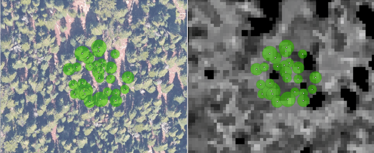
Comparison of an image with visible (RGB) light versus an image taken with LIDAR
The image on the left may be more familiar as a picture of a forest from the air, but the LIDAR image on the right encapsulates important information about the heights of trees in this portion of forest. Darker regions in the photo are lower heights (hence the road winding through the photo is black) while forested areas are shades of grey and white, denoting heights up to 30 meters.
Images taken at different heights and with different types of cameras have different inherent uses. In fact, a large portion of Scholl’s work is to associate datasets from disparate elevations and sensing techniques. This helps groups like the National Ecological Observatory Network (NEON) achieve their mission statement: providing long-term, standardized data on ecological responses of the biosphere. Scholl hopes to automate the procedure for correlating drone data with observations from both the ground and from satellites, so that NEON can more quickly and effectively process data on forests all over the continental United States.
Detection of treetops in RGB and LIDAR images
Beyond improving the techniques for data processing, Scholl’s imminent work is heavily focused on determining the degree to which a species of tree can be identified. Before she can get started on the brunt of the computational work, Scholl’s primary worry is to collect enough data for her model in the first place. Drones may be flown at will, but satellite controls are beyond the reach of Scholl.
Building a model that will consistently and successfully converge on solutions requires sufficient data. Sharing of data may be the only solution available to Scholl. To this end she is working with groups like Earth Lab at CU Boulder to promote Open Reproducible Science, an initiative that promotes learning a suite of tools specifically for sharing of the types of datasets she may need to develop her tree-classification model.
Trees are important. Many generations ago we used to live in them, now they form the structures of our homes. Trees are part of the respiratory cycle of our planet, and grow much of the food for its animals. Classification of trees is one small step to understanding how they behave as forests, and how these systems respond to disturbances. In the future, Scholl may give us the means to better understand and protect them.
By Adrian Unkeles
